- Date
- Thursday, February 18, 2016
Stay away from big slopes when the weather breaks after the storm and the sun comes out.
Avalanche Problems:
1. Wind Slabs
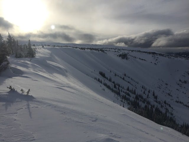
The picture below shows what wind slabs look like. Think alpine and other areas exposed to the wind. Look for wind slabs on easterly aspects AND westerly aspects, as there was a 180 degree switch in the wind direction on Wednesday (it switched from blowing from the west to blowing from the east).
2. Storm Slabs
Recent storm snow has been building up over the last week, with 30-50 cm new snow that in some places sits on a slippery crust. When the wind is blowing, it warms up or ESPECIALLY WHEN THE SUN COMES OUT, this new snow could easily slide on steeper slopes.
3. Persistent Slabs
There are suspect layers deeper in the snowpack. There is a now a crust in the upper snowpack in many areas, especially in the north and in the Kakwa. In south eastern areas like the Renshaw where the snowpack is low this year, we’re worried about sugary facets.
Pillowy wind deposits from Core Lodge area. It's sometimes hard to know how far down the slope the wind-affected snow goes, but I'd be concerned about the whole upper slope of this bowl.
Travel Advice
- Stay away from big slopes when the weather breaks after the storm and the sun comes out.
- Watch out for wind slabs on the downwind side of ridges and terrain breaks
- Ride one at a time, and group up off to the side, away from exposure from avalanches paths above.
Avalanche Activity
This size 2.5 avalanche was reported from the Torpy area on 12-February. A size 2 avalanche was reported from the Core Lodge area on 15-February.
I expect the recent storm snow to become quite reactive on steep slopes, especially those facing south, once the sun comes out.

Size 2.5 avalanche reported from Torpy on 12-Feb. Note the heavily wind-affcted snowpack.
Snowpack Summary
There has been a steady build-up of storm snow this week – most of the region has seen somewhere between 30 and 50 cm new snow. Wind slabs have been widely reported. In some places there is a crust in the upper snowpack at that 30-50 cm level. In the Kakwa and at Pine pass, there have been reports of a surface hoar layer that may be associated with the crust.
You may find another crust buried more deeply in the snowpack. Around Pine Pass, it is still possible to find an earlier weak layer of buried surface hoar from early January. In lower snow areas in the south east, there are reports of sugary facets and depth hoar in a thick layer above the ground.
Weather for this Weekend
One more pulse of snow looks likely on Friday night and then a gradual clearing trend through Saturday. Freezing level around 1400 m with strong southwesterly winds. Sunday looks like it will be bright, sunny and warm. Freezing levels around 1500 m but south facing slopes will probably feel very warm in the sun. Light winds.
Have fun and stay safe out there!
James F.