- Credit
- Lisa Gardiner
- Credit
- National Oceanic and Atmospheric Administration (NOAA)
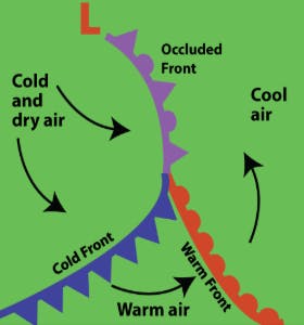
An occluded front occurs when the faster, trailing cold front of a low pressure system catches up to the slower moving warm front. This process lifts the wedge of warm air originally ahead of the cold front, cutting it off from the ground, and also lifts the warm front itself. A temperature difference across the occluded front is still observed, but it is smaller (cold to cool air instead of cold to warm air). It is represented on international weather maps by a purple line with alternating purple triangles and semicircles pointing in the direction the front is traveling in.
On Canadian surface weather maps, the occluded front is not typically analyzed. Instead, the elevated front, known as a TROWAL (trough of warm air aloft), where the cold front has lifted the warm front off the ground, is drawn.
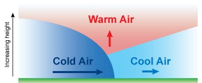
The heaviest precipitation occurs at the point where the cold front has caught up to the warm front. Here, the temperature contrasts are greatest and lift is amplified.