- Date
- Monday, February 25, 2019
Means cold snow
One of our forecasters, who also works as a researcher at SFU, sent us these great images from his work with snowpack modeling. They show computer-generated snow temperature profiles in a pair of locations in southwest BC.
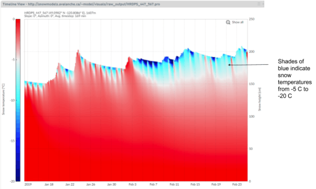
Image 1: Snow temperature profile from the Allison Pass snow model in the Manning Park area.
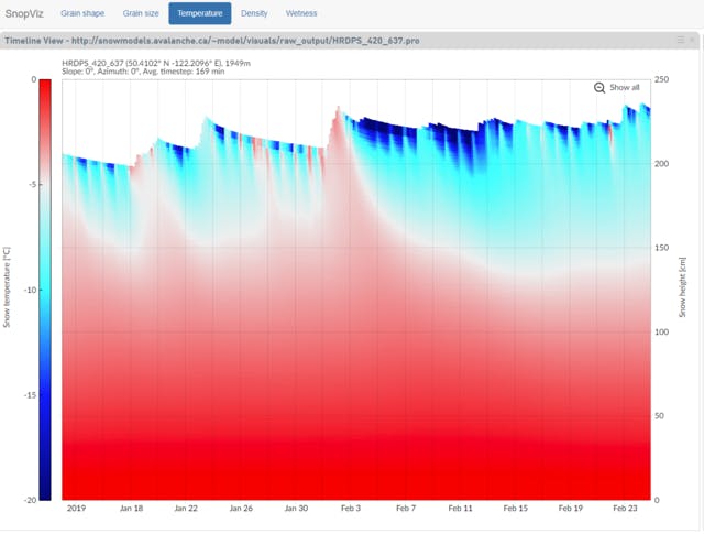
Image 2: Snow temperature profile from the Blowdown snow model in the Duffy Lake area.
The images indicate the upper snow layers are cold—much colder than you’d typically expect for this part of the world.
Cold snow is often synonymous with faceted snow. This weak snow type is impacting avalanche danger in two primary ways at this time:
- Persistent slab development—such as we’ve seen in the North Shore mountains
- Enhanced wind slab propagation—if triggered, wind slabs that have developed on top of faceted snow are likely to propagate further than usual
As a result, if you are planning to travel in the North Shore mountains this week keep persistent slabs in mind when your are planning your trips. Employ a conservative approach to choosing terrain by avoiding steep, convex slopes and by staying away from thin/variable depth/rocky avalanche terrain.
The weather forecast is calling for continued cold and clear weather through the week. We get drawn to the high country when the weather is good, so keep wind slabs top of mind when traveling in all the mountains of southwestern BC. With the current conditions, wind slabs may remain reactive for longer than usual and release wider than you may expect.