- Date
- jeudi 17 janvier 2019
Not the best surface for new snow
The old surface layer of storm snow in the North Rockies has gone through quite a bit of change since the big storms brought it to us weeks ago.
First the new snow saw strong winds that moved snow around into stiff wind slabs, extending to all aspects as winds shifted directions. Next came the warming event that rain-soaked the surface and created new rain and temperature crusts to as high as 1600 metres. Sun-exposed slopes likely saw crust formation well into the alpine. Finally, a more recent cooling trend has been breaking down old wind slabs and other dry snow into a loose, sugary surface layer of faceted snow. Meanwhile, increasingly clear and cold nights have been steadily decorating the region with a widespread new layer of feathery surface hoar crystals.
The above-mentioned surface conditions are one half of the avalanche danger picture as we look forward to a storm impacting the region this weekend. Neither crust, surface hoar, nor facets bode well for new snow forming a good bond with the surface. Areas where surface hoar has grown over a crust are particularly concerning. The second half of the picture gets filled in as we find how much new snow accumulates and how quickly it forms cohesive slabs over these dubious surfaces.
Avalanche discussion
Avalanche activity in the region has been trending downward for about a week. Although there may be some stubborn old wind slabs lingering in more extreme terrain in the alpine, it’s time to refocus our attention toward new snow problems as the next storm takes aim at the region.
The first trend to watch for will be the emergence of new wind slabs as new snow is blown into pockets below ridgecrests and around wind-exposed terrain features. Keep in mind that wind slabs build in depth and reactivity much more quickly than new snow accumulating in sheltered areas.
As snowfall continues, we’ll likely see a broadening of avalanche danger across terrain as critical slab depths expand beyond areas that are being loaded by wind. You’ll want to be ahead of the curve as this situation develops. Terrain that may initially present the need to avoid pockets of wind slab can become much more threatening as progressively widespread storm slabs build up over the weak surface conditions discussed above.
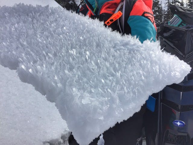
A new layer of weak surface hoar crystals has been growing throughout the region. Areas where surface hoar has grown over a crust are especially concerning.
Travel advice
- Pay attention to the increasing depth of new snow accumulations and the strength of winds at or above your chosen route.
- Tune in to the new snow’s transition from low density powder to cohesive slab. Anticipate this process to occur rapidly in areas affected by wind.
- Consider the previous surface condition (crust, facets, surface hoar) of slopes at or above your route. Visualize slab formation over this surface expanding from wind loaded pockets to more widespread storm slabs as new snow piles up.
- Hotspots for surface hoar-on-crust combos could be areas that saw rain or temperature crust formation (below 1600 metres) and avoided subsequent sun exposure as surface hoar formed on this crust (shaded aspects).
Snowpack discussion
Below the surface, our 50 cm-deep old, wind-battered, variably moist to crusty, faceting storm snow has settled well, with a strong bond now connecting it to the underlying snowpack.
Observers investigating deeper layers in the snowpack are continuing to see results that indicate they too are well bonded. Aside from surface conditions, this is as good a setup as can be hoped for as we look ahead to the storm that is set to add fresh load to the snowpack.
Deeper parts of the region have approximately 200 cm of snow at treeline elevations.
Weather
FRIDAY: Cloudy with isolated flurries bringing a trace to 2 cm of new snow. Moderate to strong southwest winds. Alpine high temperatures around -6. Slightly cooler at lower elevations under a diminishing temperature inversion.
SATURDAY: Cloudy with flurries bringing 5-15 cm of new snow, decreasing overnight. Strong to extreme southwest winds. Alpine high temperatures around -5.
SUNDAY: Cloudy with scattered flurries bringing around 5 cm of new snow and new snow totals to around 20-25 cm. Strong to extreme southwest winds decreasing over the day. Alpine high temperatures around -7.
NEXT WEEK: Current trends indicate we’ll be heading into a period of continued cloud, light flurries, and sustained moderate to strong winds over the coming week. One of several long range weather models currently shows another organized storm system impacting the region on Tuesday.