- Date
- Wednesday, November 22, 2017
Warm temperatures and rain will have different effects depending on which region you're in...
First off, we should really count our blessings that most of BC and Alberta have a substantial snowpack for this time of year—over 2 metres deep in some treeline locations—which should set us up nicely for the rest of the winter in many areas. But that is yesterday’s news… What is currently on people’s minds is the pineapple express train that has come to town, bringing much love and rain from Hawaii.
The main theme we’d like to develop in this blog post is the warm temperatures and rain will likely have different effects on avalanche hazard, depending on which region you’re looking at.
CLOSER TO THE COAST: (South Coast, Sea-to-Sky, South Coast Inland, and to a lesser extent the Northwest bulletin regions)
The short story here is most avalanche activity in this storm cycle has probably already happened, due to heavy snowfall last weekend (November 18-19) and rain early this week.
That said, the rain and warm temperatures will likely cause loose wet avalanches at virtually all elevations and aspects right through Thursday November 23rd. We’re expecting to see cooling temperatures and a lull in the stormy pattern on Friday: In all likelihood most snow surfaces will freeze, resulting in thick crusts and rock hard debris.
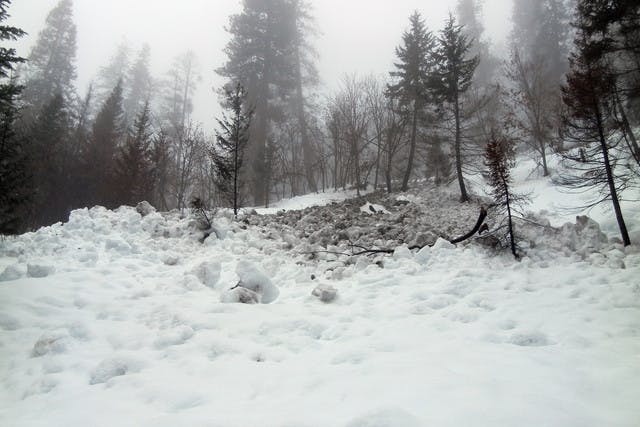
Snow is forecast to return over the weekend so any debris (see photo below) could be partially covered and difficult to see, especially in low visibility (whiteout) conditions.
TERRAIN and TRAVEL ADVICE:
Even with a decent snowpack in places, it is still November and a good time to be aware of the usual early season hazards, especially at lower elevations: stumps, rocks, open creeks, depressions and even tree wells.
More specific to the conditions in the backcountry this weekend (thanks to the warm temperatures and rain) most elevations and aspects will likely show signs of loose wet avalanche debris. In forested areas, there could be large tree-bomb craters.

- Credit
- Mike Conlan
Classic loose wet avalanche debris partially buried by new snow in some spots. Imagine yourself traversing slopes and coming across all these ‘death cookies’ frozen in place.
INTERIOR REGIONS: (Cariboos, North and South Columbias, Kootenay-Boundary, Purcells, South Rockies, Lizard Range).
It’s a different picture farther inland–the short story here is the widespread avalanche cycle hasn’t really happened... yet. Of course, we’ve had reports of sizable avalanches throughout the interior ranges, but for the most part we’re expecting many more in the coming days given the warming temperatures and forecast precipitation.
The main layers of concern (the Halloween crust and the November 9th or November 11th crust in the Cariboos) are now buried 50-100 cm. We’re into a tricky realm here… it’s hard to say for sure when the snowpack sitting on these crusts will be overloaded … will it be with another 10 cm snow? 20 cm? 30 cm?
See this excellent video for a great summary of conditions and what we might expect for the weekend with additional loading of the snowpack.
TERRAIN and TRAVEL ADVICE:
For now the best advice we can give is to be conservative with your terrain selection. Consider avoiding avalanche terrain during and immediately after periods of intense snow or rain. Recent avalanche activity is direct evidence of an unstable snowpack, but during stormy periods you don’t always have the visibility to see whether slides are running or not. There’s lots of riding ahead of us this winter and now is not the time to be pushing the terrain.
Our first forecast of the 2017–18 season will be issued on Thursday, Nov 23. Please report your observations to the Mountain Information Network or Avalanche Canada’s Facebook page.