The Ice Climbing Atlas Project is a collaboration between Avalanche Canada, our ambassador Sarah Hueniken, and Grant Statham, a visitor safety specialist in Banff National Park. The intention of the atlas is to provide an overview of historical avalanche observations from popular ice climbs in the Rockies. It is a work in progress and will be updated as information from more climbs is collected.
Avalanche observations are collected through surveys of local climbers conducted by Hueniken, a pro climber and alpine guide. Our hope is that by sharing historical data, climbers can better understand the avalanche hazard that exists on these popular climbs. We strongly encourage all ice climbers to always carry avalanche safety gear—transceiver, probe, and shovel.
ATES for Waterfall Ice Climbing
The terrain in the Atlas is rated using the new Avalanche Terrain Exposure Scale (ATES) for Waterfall Ice Climbing . The focus for climbers is on exposure time, avalanche frequency, human triggering by considering exposure to terrain traps below, and options to reduce risk by reducing exposure through choice of belay locations, alternative descents, and more.
Name | Class | Description |
|---|---|---|
Non-avalanche | 0 | Routes with no exposure to avalanches except small sluffs and spindrift. |
Simple | 1 | Routes with brief exposure to very low frequency avalanches starting from above or crossing rare short slopes. |
Challenging | 2 | Routes with extended exposure to low-frequency avalanches starting from above or several steep slopes to cross en route. Options to reduce exposure. |
Complex | 3 | Routes with extended exposure to high-frequency avalanches starting from above, or climbing through steep slopes en route with terrain traps below. Minimal options to reduce exposure. |
Extreme | 4 | Routes with continuous exposure to high frequency avalanches starting from above or en route, sustained high-angle snow slopes, and ongoing exposure to cliffs and terrain traps below. No options to reduce exposure. |
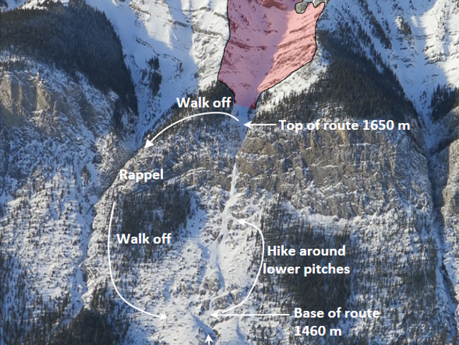
The Climbs
Cascade is a prominent waterfall that can be seen from the Trans-Canada Highway as one drives west past the Banff townsite turnoffs. Proximity to the road, a moderate climbing grade, and a sunny aspect make this an obvious tick list route for any ice climber living or travelling to Banff. It has also been the site of many unfortunate accidents and has serious avalanche terrain above it.

A 40-minute walk from around the shoreline of Lake Louise brings you to the base of this very popular Rockies classic. With natural tiers to break up pitches, a striking pillar, minimal avalanche hazard and incredible views, Louise Falls might be the most popular ice climb for its grade in the Rockies. It is not uncommon to wait in line at the base or behind the pillars for a safe time to proceed. Most climbers walk off the route to eliminate hazards to those climbing below. The walk off has more areas of concern for avalanche hazard.

First climbed in 1974, Professor Falls can be easily seen from Highway 1. It is approached from the Banff town site by either a bike ride or a 1.5-hour walk. It consists of several tiers of short steep pillars and curtains, and culminates in a crux WI4 pitch at the very end. It consists of eight steps, which allows many parties to climb the route at the same time relatively safely.

Ranger Creek is a popular venue for early season ice climbs. There are three main ice climbs here that are one to two pitches in length, as well as a few obscure mixed climbs that rarely form. It is some of the first reliable ice to form in Kananaskis country and therefore becomes very popular and busy.

Rogan’s is the deep gully left of Cascade Waterfall. It has a very short approach and, depending on the snow and debris amounts in the gully, offers many short, relatively easy steps of ice with a final full pitch of stepped ice at the top. The climb and the avalanche slopes above face southeast and therefore get a lot of sun.

First climbed in 1969, Urs Hole has roughly five pitches of moderate climbing followed by a direct finish that can be as hard as WI5. Due to its direct position under a large avalanche path, it is primarily climbed in the fall before there is much snowfall. There is often a glacier feature snow plug that lies before the last direct finish pitch due to the copious amounts of debris that piles up there.