- Date
- Friday, January 13, 2017
Unnerving trends in parts of the Rocky Mountains, areas immediately adjacent to the Rockies, and low snowpack areas in the north.
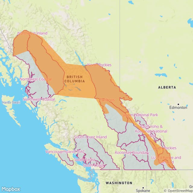
At Avalanche Canada, we have noticed some unnerving trends in parts of the Rocky Mountains, areas immediately adjacent to the Rockies, and low snowpack areas in the north (see map). The trends have resulted from the unusually cold and dry winter.
- Low snowpack areas are unusually low this year.
- The snowpack is largely made up of weak, sugary snow (facets and depth hoar).
- Riders have reported challenging travel conditions, although things may be improving.
- Many popular areas have not been heavily ridden this season due to difficulty of access so there’s a lack of the normal compaction that usually occurs and helps stabilize commonly ridden areas.
- The snowpack in sheltered areas is unsupportive. It’s common to touch ground when you get off your skis or sled.
- Exposed areas are wind hammered or wind stripped and there may be a very rapid transition between bottomless facets and hard slab areas.
Avalanche activity has been sporadic, but avalanches have occurred that are indicative of a structural problem with the snowpack. There’s been a fatal avalanche in Clemina Creek (northern tip of the Monashees) and serious close calls in Sugarbowl (northern Cariboos), Corbin (eastern Flathead Range) and Allan Creek (eastern Cariboos), not to mention a number of other, less serious incidents. These have all occurred within the area shown in orange on the map and are almost certainly related to the conditions described here.
While the snowpack is fairly weak right now, our concern is what will happen when conditions change and a thicker and more widespread “slab” layer forms on top of those sugary facets. That’s when human-triggered avalanches will become more likely, particularly in previously unridden areas, or over convex or wind-loaded features. The mountains will become much more dangerous even though there may not be a significant increase in natural avalanches. Travel will also become easier in many places, allowing access to more avalanche trigger points.
The long term weather outlook indicates a change is coming that will bring warming temperatures, new snow, and winds to many parts of the region of concern. This weather pattern will promote the widespread development of a slab over the weaker facets.
The timing and specific location of areas where the right combination of weak lower snowpack and denser upper slab will come together is still uncertain. At this time it looks as though we’ll see an evolution from northwest to southeast. Warm temperatures are forecast for the Northwest Coastal region this weekend, followed by the Northwest Inland and the North Rockies late in the weekend or early next week. If this occurs it will result in a destabilization of the snowpack.
Careful planning, conservative terrain selection, proper equipment, and good group management are the keys to staying safe in shallow snowpack areas this season. Check our forecasts, conditions reports, hot zone reports and blogs for indications as to whether this conditions exists in your riding area. If it does, or you’re unsure but think it might, select simple terrain options.
Always ride with at least one buddy. Make sure everyone in the group wears a transceiver and carries a shovel and a probe in a backpack. Only expose one person to a slope at any one time and watch from a safe distance off to the side. Have a plan for how to deal with someone who gets stuck on a slope – don’t all rush in to help at once. This article offers general guidance that applies at all times but is especially pertinent in places and at times where the conditions being discussed here exist.

The map shows a broad zone indicating where the conditions discussed above are known or suspected to exist. It includes:
- All of the South Rockies
- Northeastern areas of the Flathead (Corbin)
- The extreme northeastern tip of the Monashees (areas around Clemina Creek)
- Low snow areas of the Cariboos (Areas around Allan Creek, eastern and northern Cariboo areas including Sugarbowl, western Cariboos areas near Quesnel/Barkerville)
- All parts of the North Rockies.
- Areas around Hope Creek north of Golden.
- The Dogtooth range near Golden
- The southern Purcells around St. Mary’s and Hellroaring Creek.
- Low snow areas in the northwest, particularly around Smithers, the Telkwa, Kispiox and around Ningunsaw.
- Any area where the snowpack depth at sheltered treeline elevations measures approximately 1.5 m (5 feet) or less and where air temperatures have been consistently cold through the winter.
This map is a rough outline and should not be taken literally or used for navigation. It’s intended to provide a general idea of where more careful research for trip planning, extra caution, a conservative approach, and gathering local data to augment this and other sources of information is recommended.